Description
The ADMIRALTY Raster Chart Service (ARCS) provides raster chart coverage of international shipping routes, main ports and harbours in a comprehensive range of scales. Ideal for both bridge crews and shore based users, it combines the familiarity of traditional ADMIRALTY paper charts with the precision of satellite positioning to support decision making.
Key features of ARCS include:
Familiar, clear and easy to use
ARCS charts display the same imagery and symbols as traditional ADMIRALTY Standard Nautical Charts (SNCs). This familiarity, combined with accurate satellite positioning in an ECS or ECIDS navigation system, can improve situational awareness and help bridge crews to understand critical information at moments of peak workload and pressure.
Global coverage
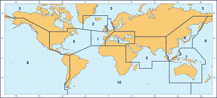
With over 3,000 official charts available, ARCS provides extensive raster chart coverage of international shipping routes, main ports and harbours in a comprehensive range of scales.
By combining the wide coverage, familiarity and ease-of-use of ARCS with AVCS, you can get the most comprehensive and trusted digital chart service available for ships trading internationally.
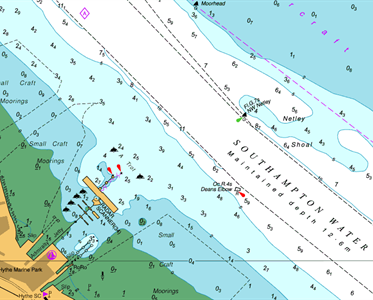
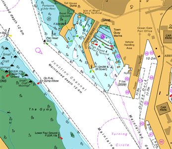
ARCS charts combine the familiarity of traditional ADMIRALTY paper charts with the precision of satellite positioning
Efficient weekly updates, including T&P NMs
Weekly updates ensure that bridge crews and shore-based teams have access to complete and up-to-date information. All ARCS customers can receive these updates via internet or CD, with the latest ADMIRALTY Notices to Mariners (NMs) applied easily and accurately in a matter of seconds. The weekly updates also include all Temporary and Preliminary Notices to Mariners (T&P NMs) generated by the UKHO’s extensive quality assurance processes.
These electronic updates reduce time and effort spent making manual updates to paper charts and minimise the risk of human error.
Official Raster Navigational Charts
ARCS is an RNC service containing digital raster copies of official ADMIRALTY paper charts, conforming to the International Hydrographic Organization (IHO) Product Specification S-61.
Raster Navigational Charts (RNCs) are a safe and reliable primary navigation alternative under certain conditions and subject to individual Port and Flag State approval, for example where ENCs don’t yet exist (see IMO resolution MSC 86 (70).
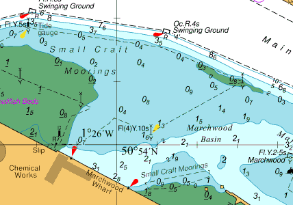
At large scales ARCS can help identify important information such as dredged depths and berth names that can be hard to find on an ENC
Efficient shore-side monitoring of your fleet
ARCS is compatible with a wide range of office-based display systems and software, giving you cost-effective, digital charting in shore-based operations. By using this software, Fleet Managers can monitor the progress of their fleet - even if their ships are using paper charts.
Cost-effective and flexible buying options
Giving you comprehensive coverage at significant cost savings and convenience, ARCS is available in 10 regional folios and one world folio.
Alternatively, for precise coverage and voyage flexibility, all raster charts within ARCS can be bought on an individual, chart-by-chart basis. There’s no need for physical chart delivery. Simply buy the licences remotely to access the charts you need.
Please call if you wish to purchase individual charts