Geodetic
GEODETIC
Geodetic is a standalone applicartion which will allow the user to carry out a series of geodetic calculations using either predefined parameters or user input data. The software was first developed in 1984 to run on a PC running under DOS and has been constantly been redeveloped in line with PC development.
The current version runs under Windows 7 and 10
Also computed:-
-
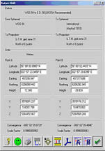
Cartesian Co-ordinates (X,Y,Z)
-
Convergence
-
Point Scale Factor
-
Radii of Curvature (Rho, Nu)
-
One Second of Arc
Methods Include
-
NADCON (North American Datum)
-
Statens KartVerk Norway.
-
Geographical Shifts
-
Grid Translations
-
OSGB
Co-ordinate conversion of data from an ACSII file.
- User defined data input
- User defined data output
- Grid to Geog conversion
- Datum Shift co-ordinates.
- User defined units.
-
Range and bearing between two point
-
Spheroid and Slope Distance
-
Forward and Reverse Bearing
-
Line Scale Factor
-
t-T Correction for TM Projection
- Great Circle Range and Bearing
-
Rhumb Line Range and Bearing
-
Length of One Nautical Mile
-
Computation from range & bearing.
-
Grid or Geographical Computation
-
Height computed from Vertical Angle
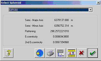
35 pre-defined spheroids including:-
Plus user entered data of:-
- Semi-Major Axis (a)
- Semi-Minor Axis (b)
- Inverse Flattening (f)
- Eccentricity (e)
Projections types include:-
- Transverse Mercator
- Mercator
- Lambert Conical
- Cassini-Soldner
- Azimuthal Equidistant
- State Plane (USA)
- Rectified Skew Orthomorphic (Borneo and Malaysia),
- Norwegian National Grid (NGO)
- Danish National Grid
- Stereographic.
Including over 150 pre-defined projection parameters.
Predefined datum shift parameters including:-
- WGS84 to OSGB36
- NADCON (North American Datum)
- Statens KartVerk Norway.
Plus user entered data of:-
-
Transformations (dX, dY, dZ)
-
Rotations (rX, rY, rZ)
-
Scale Factor (ppm)
Rotation Method
- Co-ordinate Frame
- Position Vector
-
Degrees, Minutes and Seconds
-
Degrees and Minutes
-
Degrees
-
Gradians
-
Latitude (North or South)
-
Longitude (East or West)
- Metric
- Nautical
- Imperial
- User Defined
- Day, Month and Year all Numeric
- Month as Text
- American Format Month, Day and Year
-
Hours and Minutes
-
Hours, Minutes and Seconds
-
Hours, Minutes, Seconds and Milliseconds